|
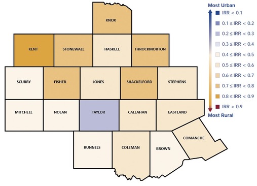
Accurate identification of counties is increasingly important in comparing counties across the country. The Index of Rural Relativity (IRR) is included in this effort to provide a common denominator in identification of four dimensions of Rurality: population, population density, extent of urbanized areas and distance to the nearest metro area. The Index of Rural Relativity varies, as expected, across the vast 19 county region. The IRR is scaled with zero representing the most urban area and one representing the most rural.
According to the Index, Kent, Stonewall, Throckmorton, Knox and Fisher counties are among the most rural of the 19 counties. These are located in the northwest area of the region, farthest away from the cities of Abilene and San Angelo. Taylor County, home to the City of Abilene is the most urbanized area in the region. Typically the areas to the east of the region, have higher indexes due to closer proximity to the cities and towns along the major Interstate 35 corridor, the greater population density of these counties and the shorter distance to metro areas. |
